Most visitors to Puerto Vallarta never leave Banderas Bay, and the bay is generous enough that you can spend two weeks without noticing. But there is a second coast that starts just south of it — wilder, emptier, and until recently a genuine expedition to reach. Mayto is its first stop, and the access question has just been rewritten.
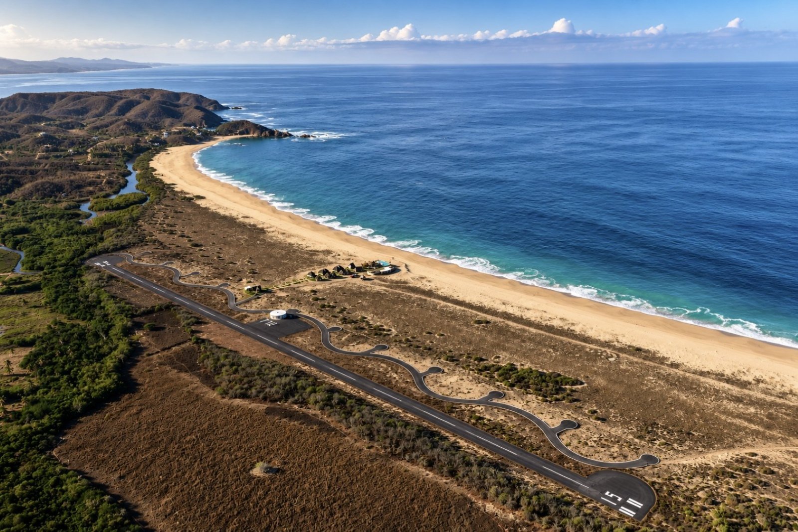
Where Mayto actually is
Mayto is a coastal community in the municipality of Cabo Corrientes, Jalisco — the cape that closes Banderas Bay to the south. Cross it and you are in the Costalegre, the long stretch of Jalisco coast that runs down toward Barra de Navidad with fishing villages, turtle beaches and half-empty bays instead of resorts.
For people who live in Vallarta this is not news. Mayto has been the weekend escape for decades: the beach you drive to with a cooler and a tent, where there are no queues, no vendors and no one else's music. It is where a local takes visitors to show them what the coast looked like before it filled up.
Option 1: the drive (about 90 minutes)
Time: roughly 1 hour 30 minutes from central Puerto Vallarta.
Route: Federal Highway 200 south toward Manzanillo → El Tuito → the coast road signposted to Mayto and Tehuamixtle.
Road surface: paved highway most of the way; the final descent to the coast is narrow, with unpaved sections.
El Tuito is worth the ten minutes it costs you. It sits high enough that the air noticeably cools, it has a proper town square, and it is the last sensible place to fill the tank and buy anything you forgot. After that the road turns west and drops toward the ocean through ranch country.
Which car, and when
- November to May (dry season). A normal car is fine if you drive patiently. This is the easy window.
- June to October (rainy season). Everything turns green and beautiful, and the unpaved stretch gets rough. A higher vehicle is a good idea, and it is worth asking about conditions before you commit to the day.
- Any month. Do not plan to arrive or leave in the dark. There is no lighting, and the potholes find you.
Add Tehuamixtle to the same drive
About eight kilometres past Mayto the coast folds into a small protected cove: Tehuamixtle, usually shortened to "Tehua". It is a working fishing anchorage with palapa restaurants built onto the rock, and it is the reason half the people making this drive make it at all — calm water you can actually swim in, boats landing the day's catch, and oysters as the local speciality. The standard local plan is beach at Mayto in the morning, lunch at Tehua, home before dark.
Option 2: the flight (15 minutes)
This is the part that changed. Mayto now has its own airstrip inside the development — a paved runway with taxiway, apron and terminal — officially inaugurated on 20 June 2025 after several years of construction and aeronautical permits.
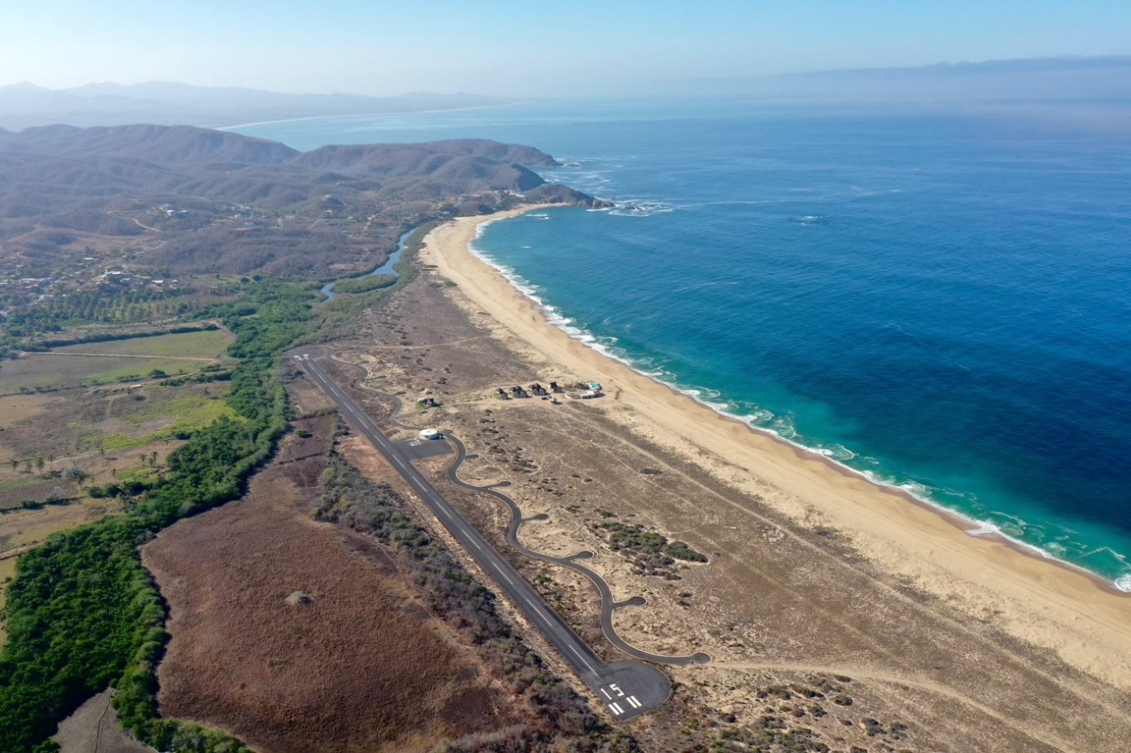
The destination's own figures are the clearest summary: zero stops, 15 minutes of flight from Puerto Vallarta, and the hour and a half by road as the alternative. You land, walk a few minutes, and you are in front of the Pacific.
Be clear about what it is
This is where a lot of coverage gets carried away, so the precise version matters. The Mayto airport is a strip for general aviation and private operation: light aircraft, executive planes, charter flights. There are no scheduled commercial airlines, no baggage belts and no international immigration. It does not replace Puerto Vallarta International — it depends on it. You still fly commercially into PVR and continue from there, either by road or by air.
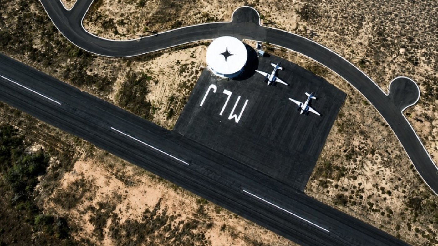
It is also, the project says, Mexico's first themed airport, and that is not just a brochure line: the taxiway curves deliberately, a tribute to the serpent of the Tenochtitlan legacy, and the shape is obvious from the air. The terminal is a circular white building with a four-pointed star on the roof, and the letters MJL are painted across the apron.
The beach itself
Long, straight and very wide. The development that operates there fronts around five kilometres of undeveloped beach, and the aerial photographs make the number believable — pale sand disappearing toward the horizon with nothing built on it, an estuary marking one boundary and hills behind.
One thing to be clear about, because it is safety information rather than a detail: this is open ocean. The waves break hard on the sand and there are rip currents. It is nothing like Las Ánimas or Yelapa inside the bay. Mayto is a beach for walking kilometres, watching sunrise, running, riding a quad along the hard sand and getting into the shallows carefully — especially with children. There are no lifeguards. If you want to swim properly, that is what Tehuamixtle is for.
Turtles
Mayto is a sea turtle nesting beach and a community turtle camp has worked the sand there for years. Depending on the season, hatchling releases take place at dusk — one of the main reasons Vallarta families make the drive. Dates follow the nests, not a calendar, so ask when you arrive. On a nesting beach the etiquette is simple: keep vehicles off marked areas, take your rubbish with you, and never shine a light directly at a turtle.
Where to sleep
For years the answer was a couple of small guesthouses or your own tent. Now there is also the development's own lodging: beachfront rooms under palapa roofs, a few steps from the runway, with a pool and the common area facing the water. It is small on purpose — a handful of suites on an enormous beach.
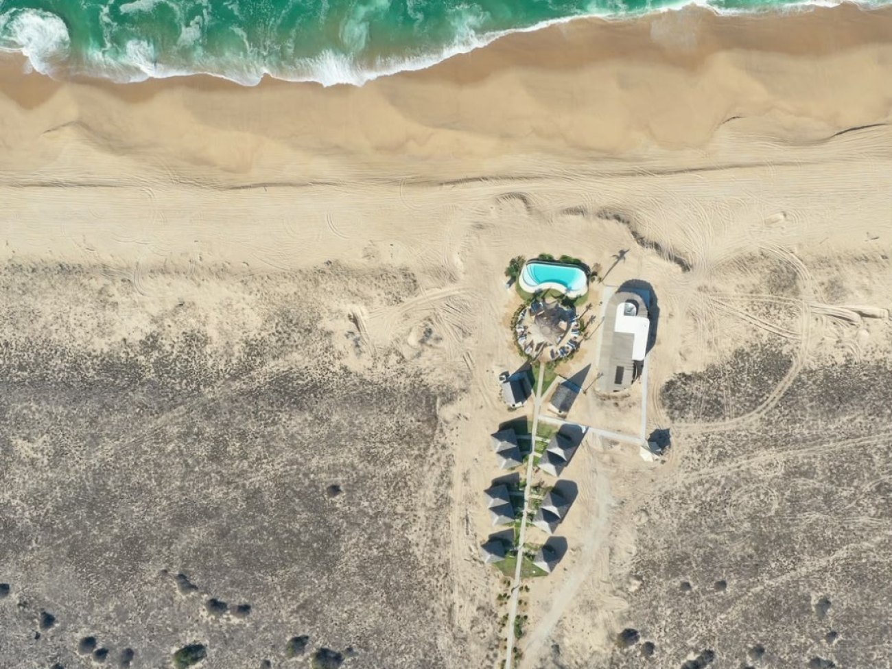
There is a single category of suite — king bed under palapa, private terrace, ocean view — open year round, with local hosts on site. Booking is direct: mayto.com/booking, reservations@mayto.com or +52 33 3822 5731. If you are flying in, they will assemble the flight, the room and the park visit as a single arrival.
The Parque Astrológico, and the sky above it
The development's long-term project is the Parque Astrológico: twelve roundabouts, one per zodiac sign, acting as gateways to twelve Zodiac Temples, with six open-air themed experiences and an observatory.
Set expectations correctly: it is being built in phases. What operates today is the air access and the beachfront lodging; the first temple, Virgo, is projected for 2027. The argument that already works, and that nobody had to build, is the sky. With no town anywhere near, there is almost no light pollution and the Milky Way is visible to the naked eye — which is exactly what astrotourism needs and exactly what the bay cannot offer.
What to bring
- Cash. Rural coast; do not count on an ATM or on card payment.
- A full tank. Fill up in Vallarta or El Tuito, not on the way down.
- Downloaded maps. Mobile signal is intermittent.
- Sunscreen, repellent, a hat and water. There is no natural shade on that beach.
- A torch. No street lighting after dark.
- Closed shoes if you plan to walk the estuary side.
Day trip or overnight?
You can do it in a day from Vallarta, and many people do — leave early, beach in the morning, lunch in Tehuamixtle, back before dark. But three hours of driving for a beach you have to leave at four in the afternoon is a poor trade, because the strongest argument for Mayto happens after sunset: total silence and a sky with the Milky Way in it. If you can give it a night, give it a night.
Frequently asked questions
How long is the drive from Puerto Vallarta to Mayto?
About an hour and a half, via Highway 200 through El Tuito and then the coast road. The last stretch is narrow and partly unpaved.
Can I fly there on a commercial flight?
No. The Mayto strip handles general aviation, private and charter flights only. Commercial travellers fly into Puerto Vallarta International and continue by road or in a light aircraft — about 15 minutes in the air.
Do I need a 4x4?
Not from November to May, when a normal car driven carefully is fine. From June to October a higher vehicle is advisable, and it is worth checking road conditions before you set out.
Can you swim at Mayto?
Only with care and only in the shallows. It is open ocean with heavy shorebreak and rip currents, and no lifeguard service. For a proper swim, go to the cove at Tehuamixtle.
Is there anywhere to eat?
Options at Mayto itself are limited and rustic. The reliable food stop is Tehuamixtle, eight kilometres on, where the palapa restaurants on the cove are known for oysters and the day's catch.
What is the best time of year to go?
November to May for dry weather and the best road conditions. June to October is greener and more dramatic, with a rougher sea and a harder drive.
When should I go to see the stars?
Around the new moon. A full moon washes the sky out and the Milky Way disappears.
Is it suitable for children?
Yes for the beach, the turtle releases and the drive, with the obvious caveat about the water — keep children in the shallows and within arm's reach, not just in sight.
Mayto is what the Jalisco coast looks like with the noise removed: five kilometres of empty sand, an estuary, turtles, real ocean and a sky that still shows the Milky Way. The difference now is that you can be there in fifteen minutes of flight, sleep with the sound of the Pacific and visit a zodiac park that has no equivalent in Mexico.
The full destination — airstrip, beachfront hotel and Parque Astrológico — is at mayto.com. If you are still building the rest of the trip around the bay, our own guide to Vallarta's secret beaches and the Puerto Vallarta adventure map cover the closer ground, and the Vallarta Surf crew know more than anyone about how this open coast behaves. En español, la misma costa está cubierta en la guía de Puerto Vallarta.
Going further south?
The Costalegre starts here and runs for another 200 kilometres.
Explore beaches →